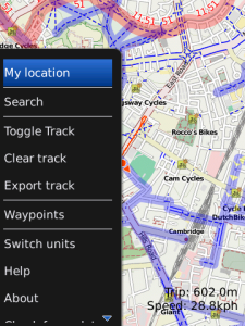
Cycle Maps
Go cycling a lot? Get Cycling maps that highlight national and local cycle routes in your area. App includes a cycle computer showing you distance and speed requires GPS. Record the route you rode and see it on the map, or upload it to our website and see it on Google Earth. Also included is waypoint navigation so you can mark particular points.
High quality maps in a fast and responsive app, that also supports a host of other GPS related features.
Use the volume control or 1/3 keys to zoom in and out
Whether you want a simple cycling map application or something to go Geocaching with Cycle maps is it. Providing detailed maps of most of the world, including not just roads but other features such as walking paths, cycle routes, bus and train stops, businesses etc.
The application uses your phones GPS to show you where you are, what direction youre cycling in and what your speed is. Quickly navigate back to fixed points such as where you parked your bike or your friends house by marking the spot.
Maps are based on opencyclemaps.org please checkout the website to see what maps in your area look like.
Application loads instantly excluding map downloads
Smooth interface
Waypoints export in GPX format with track
Find your bike by marking it on the map
Records track, exports to GPX format map them in Google Earth at aztux dot com
Trip meter/odometer see how far youve travelled.
Speedometer
Compass
Search feature
Multiple units km/miles
Lattitude and Longitude display
App Name:Cycle Maps
App Version:1.0.7
App Size:81 KB
Cost:US$4.99 USD