TMJ-Mobile
TrackMyJourneyMobile: A multifunction Recreational Outdoor Navigation and Mapping Application.
Uses the phones internal GPS or an external bluetooth GPS to record a track of your activities eg walking/running/cycling/driving etc giving detailed statistics including avg/max speed, distance, time, ascent/descent, calories burnt, etc.
Comprehensive map display functions including online and offline Rastermaps and online OpenStreetMapbased 2D/3D Vectormaps with local street/POI gazetteer, topographical contour lines and highlightable OSM Bus/Walking/Cycle routes.
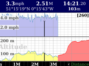
Graph display showing Speed and Altitude vs Distance or Time, plus Speedometer, Altimeter, Bearing and other Gauges.
Live position/track upload to TrackMyJourney website for sharing your location with friends and/or storing an archive of your outdoor activities.
Basic online turnbyturn routing powered by CloudMade or CycleStreets OpenStreetMapbased APIs, with an Altitude profile of the route useful when cycling to see where the next big incline will be!.
Other functions include WaypointProximity alerts, Stopwatch recording time and distance, GPS data logging to GPX/NMEA file, manual PointbyPoint Routing, Waypoint synchronisation with the TrackMyJourney website, and much more…
Visit www.trackmyjourney.co.uk for further details and to signup for a free account required for the webfunctions within TMJMobile
Please see www.trackmyjourney.co.uk/blackberry for BlackBerryspecific notes and troubleshooting.
Note: some features are limited in this free version of TMJMobile see the TrackMyJourney website for info on upgrading to the Full version.
App Name:TMJ-Mobile
App Version:0.7.9
App Size:640 KB
Cost:FREE