Marine Map Navigator
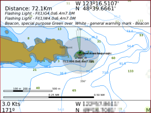
Mobile Marine Navigator is an aid for marine navigation that integrates your mobile devices GPS data with vector electronic navigational chart ENC. The application displays the ENC along with the position, heading and speed of the ship. Mobile Marine Navigator displays NOAA Electronic Navigational Charts NOAA ENCs; a collection of nearly 1000 charts which cover all coastal areas in the USA and its territorial waters. The application can use your location to determine the optimal chart for use, or the chart can be manually selected. In addition Mobile Marine Navigator will load any ENC in S57 format, the standard of the International Hydrographic Organization IHO.
Since Mobile Marine Navigator uses these ENC charts it is able to display a wider range of data on certain types of object than traditional paper charts allow. Also since they are vector charts zooming doesnt affect the quality of the maps display so lines and point objects remain the same size at any map scale. It also has the capability to show denser data.
In addition Mobile Marine Navigator allows KMLGoogle Earth Paths and Waypoints to be both imported and exported. It also uses your current location to determine marine weather and tidal information whenever you have data service.
Current Map Sets include NOAA USA Coastal Maps GPS Based Selection and Army Corp of Engineer River maps Manual Selection. Does not include CHS Canadian Charts. If you live in Canada check if the NOAA covers your region.
App Name:Marine Map Navigator
App Version:1.1025.0
App Size:1003 KB
Cost:US$29.99 USD