US ATONS
The US ATONS App was created in an effort to offer the marine navigator a simple easy to use set of quick reference cards for marine navigation in US waters. As part of the information package the International Flag Code System is also included.
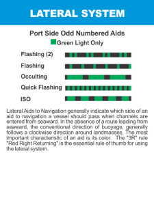
Lateral System, NonLateral System, Dayboards, Isolated Danger, Range Dayboards, Regulatory Marks, The Intercoastal Waterway ICW, Special Buoys, Distress Signals, Operating Rules of the Road, The Cardinal Buoys and the International Flag Code System are all here in one convenient location for quick reference when boating on US waters.
The US ATONS are a set of 40 cards laid out in the format of a playing card. Each card has a corresponding icon designed to jump you directly to the page with the information for that navigation symbol. You may have to scroll left or right or up and down to display all the information on the card. Once you are on a page you can scroll left and right to move through the entire deck of cards, if your device has one you can press the scroll pad button to advance through the pages as well. Pressing your back button will take you back to the icon page. You may notice a slight lag due to page buffering if you are scanning through the pages quickly, please be patient while buffering catches up to your movements.
Boaters call navigation rules The Rules of the Road. These rules define the roles and responsibilities of vessel operators. If all operators obeyed these rules, most accidents could be avoided. One of the reasons the Rules of the Road exist is to keep boats from colliding with each other and with other objects. Collisions are the number one type of accident on the water; boaters should review and remember the Rules of the Road.
The Rules vary slightly depending on whether you are boating on inland or on international waters. As an example, when operating on inland waters, sound signals are signals of intent; when operating on international waters, they are signals of action.
Please note that marine navigational systems are not standardised worldwide. Our understanding is that the cardinal system is universal, but the lateral system is divided into two regions. Most countries operate with the port red buoys showing on the left hand side when entering a channel with an incoming tide, but in the Americas, the system is reversed.
While every effort has been made to ensure the accuracy of the information presented by this App, it should only be used as a learning aid, and not to replace course materials and official publications.
The developer welcomes any information about possible inaccuracies, and suggestions for improvements.
App Name:US ATONS
App Version:1.0.0
App Size:2554 KB
Cost:US$8.99 USD